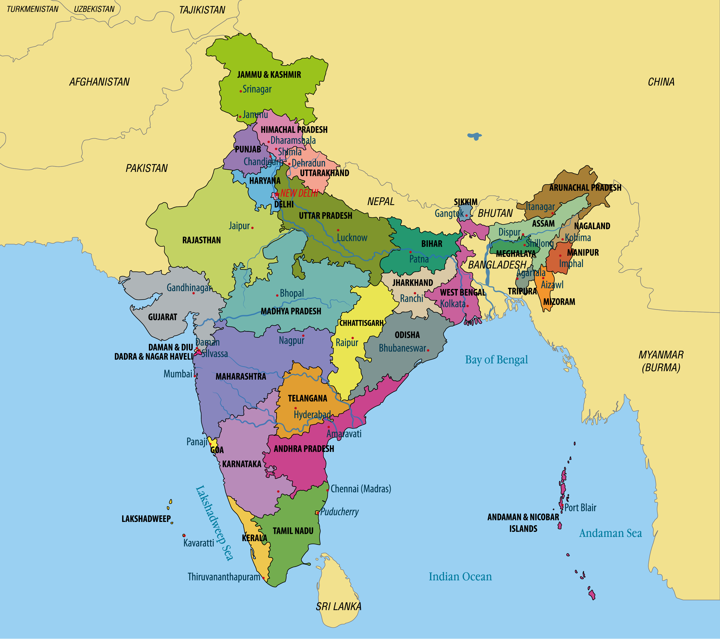
Neighbouring countries of India – Know all countries sharing land or maritime border with India

Our country India is in the northern hemisphere and in the Eastern hemisphere longitudinally. Area-wise, India is the 7th largest country on the Planet. Due to its large size, it shares land and sea borders with a large number of countries. In today’s post, we are going to provide a list of India’s neighbouring countries.
As far as land borders are concerned, Bangladesh shares the largest border with India. Different questions related to neighbouring Countries of India are often asked in exams. Go through this post to know all neighbouring countries of India along with some interesting
Neighbouring Countries of India as per Land Borders of India
India shares its land borders with 7 countries. However, the government of India also recognizes the 106 Km land border that India shares with Afghanistan. But, the fact is that India’s border with Afghanistan is in POK (Pakistan Occupied Kashmir). Given below is the list of countries that shares a land border with India.
Bangladesh
Length of the land border – 4096 Kilometers
Force Guarding the border – Border Security Force (BSF)
States and Famous Points/ Districts on India – Bangladesh Border
- Assam – Mankachar, Karimganj, Guwahati Steamer Ghat (Dhubri district, India), Dhubri Steamer Ghat (Dhubri district, India), Mahisasan railway station, Golokganj, Silchar Railway Mail Service.
- West Bengal
- Meghalaya – Baghmara, Bholaganj, Borsara Land Customs Station, West Garo Hills – Bakshiganj, Tura-Nalitabari, Shellabazar, Gasuapara, Ryngku, Balat.
- Tripura – Srimantapur (Sipahijala district), Dhalaighat (Dhalai district) – Kumarghat (Sunamganj division), Khowaighat (West Tripura district) – Balla (Habiganj division), Manu (Dhalai district) – Chatlapur (Sylhet division ), Muhurighat (South Tripura district) – Belonia (Feni division ), Old Ragnabazar (North Tripura district)
- Mizoram – Kawarpuchiah integrated checkpost (inaugurated by PM Narendra Modi in October 2017)
- Demagiri (Lunglei district)
Overview – India Shares its Biggest Land Border with Bangladesh.
Bhutan
Length – 578 Kilometres (359 miles)
Force guarding the border – Sashastra Seema Bal
States on India – Bhutanese Border – Assam, Arunachal Pradesh, West Bengal, and Sikkim.
Overview – It is an open Border
China
Length – 3,488 kilometres (2,167 mi)
Force guarding the border – Indo-Tibetan Border Police and Special Frontier Force
States and Famous Points/ Districts on India – Chinese Border – Jammu and Kashmir, Himachal Pradesh, Uttrakhand, Sikkim, and Arunachal Pradesh
Overview – Indian Border with China is also known as McMahon Line
Myanmar
Length – 1643 Kilometres (1021 miles)
Force guarding the border – Assam Rifles and Indian Army
States and Famous Points/ Districts on India – Myanmar Border –
States – Arunachal Pradesh, Manipur, Mizoram, and Nagaland
Bazaar and haat on the border
- Changlang district (Arunachal Pradesh) – Pangsau Pass (Nampong), – Pangsau, Kachin State, Chingsa (Khimiyang Circle) – Langhong, Kachin State, Makantong (Khimiyang Circle) – Ngaimong, Kachin State
- Tirap district (Arunachal Pradesh) – Wakka/ Pongchau-Wakka (Vidhan Sabha constituency)[Pongchao]/ Lazu – Tirap, Kachin State
- Ukhrul district (Manipur)- Kongkan Thana – Aungci, suggested by State Government
- Chandel district (Manipur) – New Somtal – Thenjen, or Khampat
- Churachandpur district (Manipur) – Behiang – Khenman, or Chikha
- Lawngtlai District (Mizoram)- Hruitezawl, Lawngtlai district – Varang
- Champhai district (Mizoram) – Hnahlan – Darkhai, Vaphai – Leilet
- Saiha district (Mizoram) – Nviaphia, Chakhang, Saiha district – Nviaphia
- Tuensang district (Nagaland) – Avakhung – Layshi are 32 km from each other, Pangsha – Lahe/ Hkamti District HQ are 60 km from each other.
- Mon district (Nagaland) – Phek district – Pansat are 10 km from each other
- Phek district (Nagaland) – Pansat are 10 km from each other, Molhe – Pansat are 10 km from each other
Overview – The land border to India-Myanmar is also known as India – Myanmar Barrier
Nepal
Length – 1752 Kilometres (1089 miles)
Force guarding the border – Shashastra Seema Bal
States on India – Nepal Border – Sikkim, West Bengal, Bihar, Uttar Pradesh, and Uttrakhand
Overview – It is an open border
Pakistan
Length – 3310 Kilometres (2060 miles)
Force guarding the border – Border Security Force
States on India – Pakistan Border – Jammu and Kashmir, Punjab, Gujarat, and Rajasthan
Overview – The Indo-Pakistan border is also known as Radcliffe Line.
Sri Lanka
Length – 0.1 Kilometres (0.062 miles)
Force guarding the border – Border Security Force
States and Famous Points/ Districts on India – Sri Lanka Border
Overview – Separated from India by Gulf of Mannar
List of Neighbouring Countries of India as per Maritime Borders of India
According to United Nations Convention on the Law of the Sea, India shares Maritime Borders with the following 7 countries.
- Bangladesh – New Moore Island was a small uninhabited offshore sandbar island in the Bay of Bangel near India-Bangladesh Border.
- Indonesia – The southern-most point of India i.e. Indira Point is on the India-Indonesia Maritime Border.
- Myanmar – Landfall island is near the India – Myanmar Maritime Border.
- Pakistan – Sir Greek formerly Ban Ganga is a tidal estuary in the uninhabited marshlands of the Indus River Delta on the border between India and Pakistan.
- Thailand – Similan Islands are practically the maritime border between India and Thailand.
- Sri Lanka – Katchatheevu is an island on India – Srilanka border.
- Maldives
Indian Navy shoulders the responsibility of guarding Indian Maritime Borders with all these 7 countries
Frequently Asked Questions
No, UAE is not a neighbour country of India.
Dhivehi
Beijing
Bangladesh
Nepalese Constitution Day is celebrated on 19th September every year.


